About INFOS
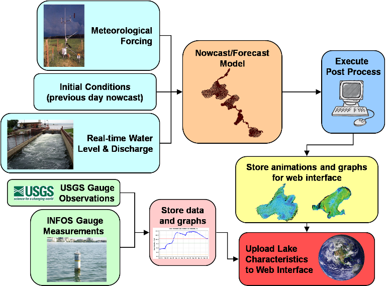
INFOS Structure

INFOS Data - INFORMATION
There are currently 11 stream gages within the Yahara Lakes system. Depending on their location, they are funded by Dane County, Wisconsin Department of Natural Resources, City of Madison, City of Middleton, and Madison Metropolitan Sewerage District, and are operated by the USGS. The gauging stations will be integrated within the INFOS platform to provide real-time observed measurements. The observed gauging stations measure water level, discharge, temperature, suspended solids, and phosphorus measurements.
While the current gages provide basic information for the Yahara Lakes, there are still several un-gaged tributaries. To fill the information data gap, the proposed project will install INFOS measurement stations for un-gaged tributaries to provide water level, velocity, temperature, and sediment concentration data. Spatial water level information would be obtained with automated calibrated pressure sensors. Stream or river velocity is collected using an Acoustic Doppler Current Profiler (ADCP), which can be placed within the lake for lake circulation or within a tributary to obtain flow information. Vertical column temperature will be determined using thermistor chains attached to a buoy located in the lake. Sediment concentrations are characterized using Optical Backscatter Sensors (OBS). Video capturing devices or webcams will be installed along the Yahara Lakes to provide real time visual information and will be incorporated into the web interface. Depending on the location and long-term needs, each station will be installed on a permanent or temporary basis following analysis and review of the data. A permanent station will consist of a wireless system to transmit data from the lake instrument and integrate into the INFOS platform.
INFOS Models - INTEGRATION
Numerical models have become important tools to evaluate responses of natural water systems. Several studies and past research have focused on using numerical models to assess the response of natural systems to changes in water level regimes, changes in channel operations, construction of engineering facilities, and climate variations. The models are also used in conjunction with field measurements to understand the basic functioning of these systems. As lake and river systems are complex natural systems influenced by a variety of external factors, there is a need to develop and incorporate numerical modeling to better assess the processes within the Yahara Lakes system.
The Yahara system is a complicated, mostly man-made system with its four dams (Mendota, Waubesa, Kegonsa, and Stoughton), channel constrictions, and irregular channel geometries. There is a need to spatially evaluate the Yahara Lakes through numerical modeling to further understand the complex system. There has been no modeling effort to date to accurately represent the spatial properties of the Yahara Lakes.
A suite of models will be integrated to predict the water information in the Yahara Lakes, including:
- Spatial water level fluctuations
- Circulation and water flow movements
- Sediment transport
- Nutrient fate
- Thermal structure
INFOS Water Portal - INTERFACE
The INFOS water portal is being developed to provide a web browser interactive interface. Once the interface is configured and the real-time input streams are setup, we will develop automated codes to streamline the model execution, plot the model simulation results, and post figures to the website. Data will also be displayed in a web browser. Note that we aim to use real-time data to drive a numerical model, which requires no need for user interaction to download data sets. Dane County staff must manually enter the current lake level information each day. This web platform component will eliminate that requirement. Therefore, the final outcome of the model will be displayed over an Internet connection in real-time. We plan to develop a Graphical User Interface (GUI) to allow management applications that would allow for customized simulations. The web interface will combine both modeling and observed results under one platform. We also plan to install web cams along the Yahara Lakes and these video streams will be incorporated within the water portal interface. This integration of all available data and numerical modeling results will be advantageous to effectively assess and develop future management strategies for the Yahara Lakes.


